Summary
This article explains how AI-powered predictive risk intelligence platforms help energy companies evaluate future drilling regions by combining geospatial analytics, multi-source data integration, and incident correlation. It also shares XB Software’s experience building a multi-tenant decision-support platform for the energy sector.
Every drilling project begins long before a rig reaches the site. Before equipment is mobilized or exploration activities begin, operators must decide whether a region represents an acceptable operational risk. Those decisions influence everything from budget planning and logistics to environmental compliance and long-term project viability.
Energy companies already have access to vast amounts of structured and unstructured data generated by internal systems, public databases, satellite imagery, GIS layers, government agencies, weather services, news outlets, and industrial monitoring platforms. So, the real difficulty lies in connecting these signals and determining which ones are most relevant to future drilling regions. This is where a risk intelligence platform based on predictive analytics can provide significantly greater value than traditional reporting tools.
Why Drilling Risk Assessment Needs a Predictive Analytics Platform
Selecting a future drilling location has always involved uncertainty. Even regions with favorable geological conditions may present operational challenges that only become visible after drilling activities have started.
Traditionally, drilling risk assessment has relied on geological surveys, historical drilling reports, expert knowledge, and operational experience. However, there are many additional factors that drive the decision-making process: infrastructure availability, transportation corridors, environmental constraints, regional stability, historical incidents, regulatory changes, etc. Thus, the International Energy Agency identifies extreme weather as one of the fastest-growing threats to energy security, alongside geopolitical risks, cyberattacks, and supply chain disruptions, making broader operational risk assessment increasingly important.
Key Risk Categories Behind Drilling Region Assessment
Successful drilling hazard prevention depends on understanding how different categories of risk influence one another. While every project has unique characteristics, most borehole drilling risk assessment initiatives evaluate several common dimensions.
| Risk category | Example factors |
| Geological risk | Rock formations, fault zones, reservoir uncertainty, historical drilling performance |
| Environmental risk | Protected areas, water resources, environmental regulations, ecological sensitivity |
| Infrastructure risk | Roads, pipelines, power availability, logistics hubs, emergency response access |
| Weather and climate risk | Seasonal flooding, extreme temperatures, storms, long-term weather exposure |
| Operational risk | Historical incidents, equipment availability, workforce accessibility, supply chain reliability |
| Regional and security risk | Political stability, transportation restrictions, public safety incidents, regulatory changes |
The complexity of drilling risk assessment rarely comes from evaluating a single category. Instead, it arises from understanding how multiple risks overlap within the same region.
For example, an area may offer excellent geological potential but also suffer from poor infrastructure proximity, repeated weather disruptions, and increasing transportation incidents. Individually, each issue may appear manageable. Combined, they can substantially increase overall project risk. So, it’s vital to remember that many factors can affect whether a promising drilling location ultimately becomes a successful investment.
Many energy companies still evaluate these factors using separate reports created by different departments. The result is fragmented decision-making.
Without multi-source data integration, different stakeholders often work with different versions of reality. Critical relationships between datasets remain hidden, making it difficult to identify high-risk zones before operational planning begins.
A risk monitoring platform addresses this challenge by consolidating information from multiple domains into a single operational view. Instead of simply documenting past events, it helps organizations to evaluate how today’s conditions may influence tomorrow’s drilling activities and support more informed drilling risk planning.
Geospatial Risk Intelligence for Future Drilling Region Assessment
When discussing drilling risks, maps are often viewed as simple data visualization tools. In reality, geospatial risk intelligence plays a much deeper role.
Every operational event has a geographic context. Infrastructure failures occur near transportation routes. Weather patterns affect specific regions. Environmental restrictions overlap with planned drilling locations. Historical incidents cluster around particular operational corridors.
Without spatial analysis, these relationships remain difficult to recognize.
A geospatial risk intelligence software combines traditional GIS solutions with operational analytics, enabling organizations to evaluate multiple spatial datasets simultaneously.
Instead of viewing isolated reports, decision-makers can analyze:
- regional risk maps;
- historical incident density;
- infrastructure proximity;
- environmental constraints;
- protected areas;
- terrain complexity;
- weather exposure;
- transportation accessibility.
Besides obtaining a better map, energy companies also get a richer understanding of how different operational conditions interact across future drilling regions.
For example, two locations may appear equally attractive from a geological perspective. However, once historical incident clusters, climate risk, logistics infrastructure, and environmental constraints are layered together, one region may present substantially lower operational uncertainty.
This ability to compare regions using multiple contextual layers transforms geospatial analytics into a strategic planning tool rather than a reporting feature.
This is why many organizations invest in custom energy management software development, allowing them to build platforms tailored to their own operational data, regional priorities, and risk assessment workflows rather than relying on generic analytics tools.
How XB Software Built a Predictive Risk Intelligence Platform for Drilling Region Assessment
One of XB Software’s recent energy projects demonstrates how fragmented operational data can be transformed into predictive risk intelligence for drilling region assessment.
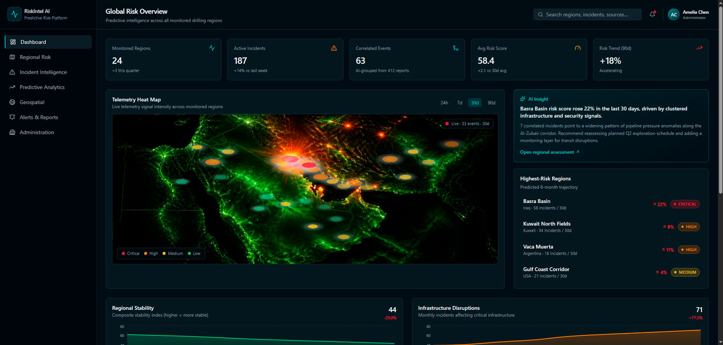
System dashboard created with AI assistance to help the client understand the product vision
The client specialized in industrial inspections and operational intelligence services supporting organizations responsible for evaluating future drilling opportunities across multiple regions, including parts of the Middle East and North America.
Before drilling projects moved into execution, exploration and operations teams needed to understand whether a region represented an acceptable level of operational risk.
The information already existed. Every day, analysts reviewed news publications, government advisories, weather services, transportation updates, infrastructure reports, and regional incident databases. Findings were consolidated into spreadsheets before periodic intelligence reports were distributed to decision-makers.
Initially, this process worked reasonably well. As the number of monitored regions increased, however, the limitations became increasingly obvious.
Analysts spent far more time collecting information than interpreting it. Similar incidents appeared in multiple reports. Important developments were buried beneath hundreds of routine updates. Executives received large volumes of information but struggled to identify which developments genuinely affected future drilling decisions.
At first, the initiative appeared relatively straightforward. The requested functionality included familiar capabilities:
- collect information from multiple external sources;
- classify incoming events;
- remove duplicate records;
- generate dashboards;
- provide alerts for significant incidents.
On paper, the project resembled a conventional AI search monitoring platform or intelligence aggregation solution. However, interviews with analysts, operational planners, regional coordinators, project managers, and executives revealed a consistent pattern: Very few strategic decisions depended on a single news article or isolated incident.
Instead, stakeholders wanted answers to broader operational questions:
- Is regional stability improving or deteriorating?
- Are infrastructure disruptions becoming more frequent?
- Are transportation corridors becoming less reliable?
- Is weather volatility increasing compared to previous years?
- Could current incident trends indicate elevated operational risks six months from now?
The discovery process revealed that the client actually needed a decision-support platform capable of transforming fragmented operational data into predictive risk intelligence.
As the project evolved from event monitoring to predictive risk intelligence, one technical challenge became critical: identifying when multiple reports described the same real-world incident.
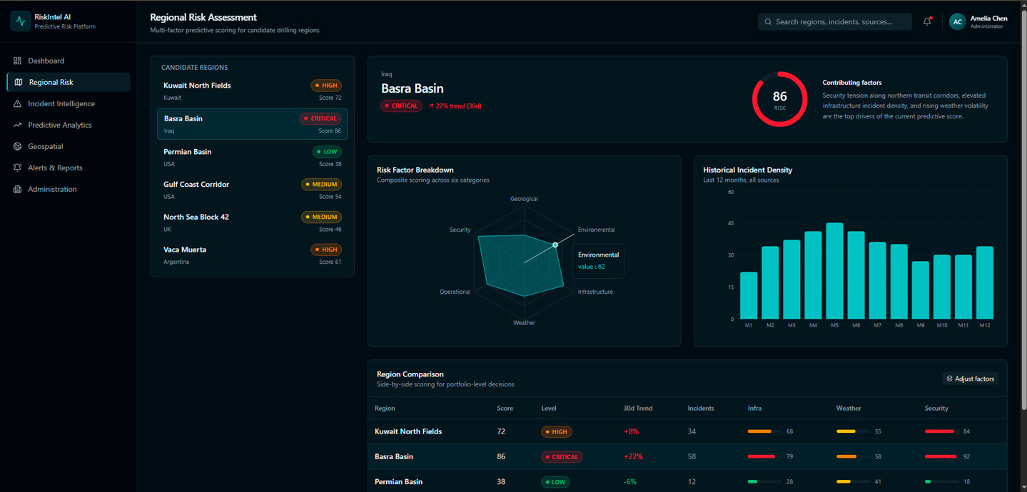
Multi-factor predictive scoring for candidate drilling regions
A single pipeline disruption, for example, could appear in international news, government advisories, transportation bulletins, analyst reports, and open-source intelligence feeds — each emphasizing different aspects of the event.
Traditional duplicate detection methods proved unreliable. Keyword matching often treated identical incidents as separate events, while basic similarity algorithms sometimes merged unrelated incidents from the same region. Both scenarios distorted the operational picture.
Instead of building a traditional news aggregation engine, XB Software suggested an AI-powered incident correlation framework. Rather than comparing articles, the system determined whether incoming reports referred to the same event by evaluating multiple contextual signals, including location, timing, involved assets, source credibility, historical context, and semantic similarity. Each report contributed to a confidence score that either enriched an existing incident or created a new one, resulting in cleaner, more reliable risk intelligence for decision-makers.
During discovery, XB Software found that risk is highly contextual. A weather event, infrastructure failure, or security incident may be critical for one organization but insignificant for another, depending on its assets, operating regions, and business priorities.
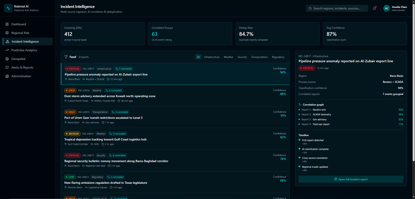
Multi-source ingestion, AI correlation & deduplication
Instead of using a single universal model, we designed a multi-tenant predictive risk intelligence platform where each customer operates within an isolated workspace configured with its own monitored regions, data sources, incident priorities, reporting preferences, and risk thresholds.
While all tenants share the same AI engine, each interprets operational signals through its own configurable risk model. This allows the same event to produce different risk assessments based on each organization’s operational context, making the platform flexible enough to support diverse energy companies and drilling environments.
As the platform evolved, stakeholders realized that the greatest value came not from monitoring individual incidents but from identifying long-term patterns.
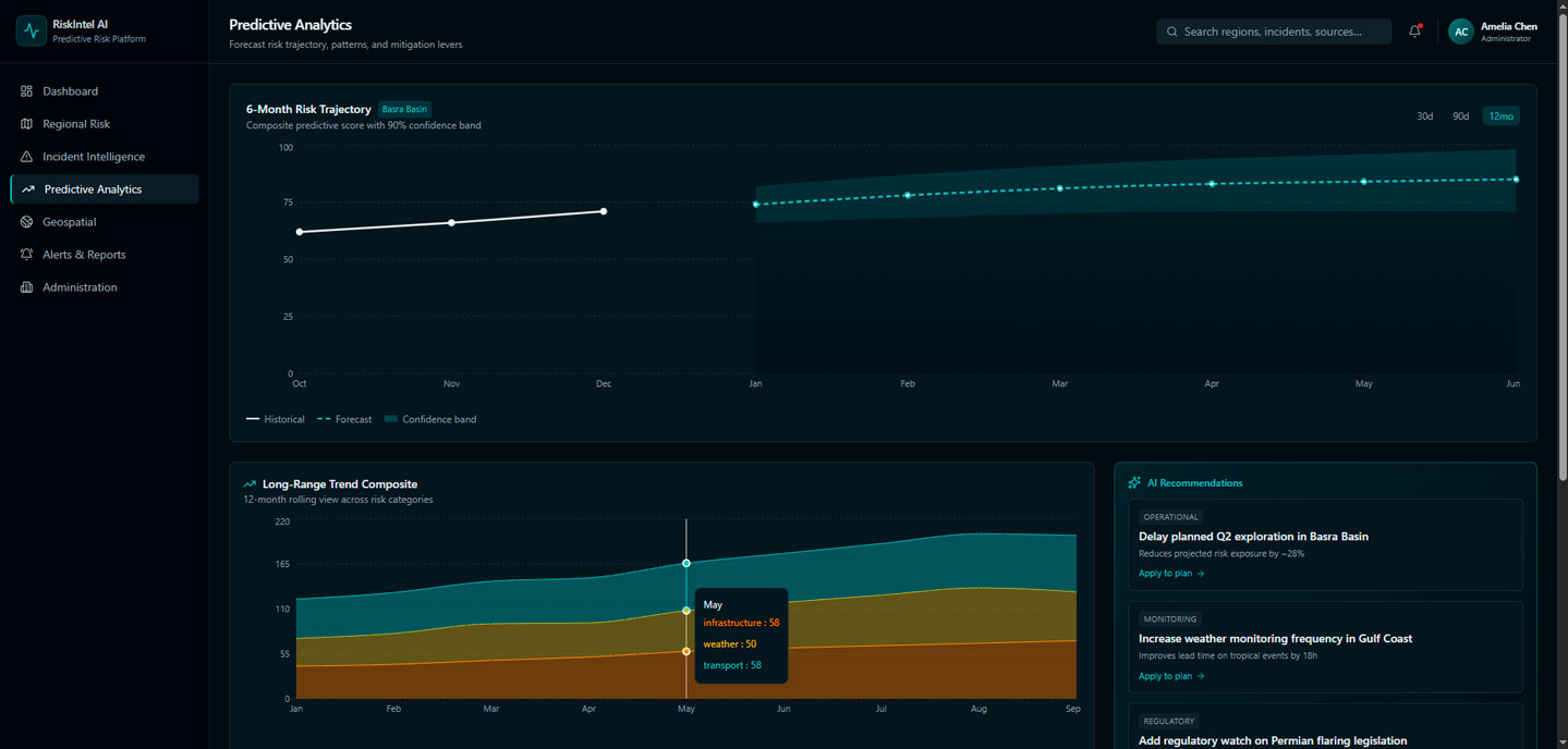
Forecast risk trajectory, patterns, and mitigation levers — AI-assisted system prototype
A single transportation disruption or weather event rarely influenced drilling decisions. However, recurring infrastructure failures, weather disruptions, regulatory changes, or security incidents across the same region often indicated emerging operational risks.
As a result, the solution evolved from a risk monitoring platform into a predictive risk intelligence platform. Instead of simply reporting current events, it helped organizations to identify accelerating risks, compare regional stability, and evaluate how historical trends could affect future drilling regions.
Rather than predicting the future with certainty, the platform reduced uncertainty by highlighting meaningful changes early, giving exploration and operations teams more time to assess risks and make informed planning decisions.
Read Also How Custom Software Helps Solve Oil and Gas Scheduling Challenges
How to Build an AI-Powered Predictive Risk Intelligence Platform for Future Drilling Regions
Developing a predictive risk intelligence platform requires much more than aggregating operational data. The goal is to transform fragmented information into actionable insights that help exploration and operations teams to evaluate future drilling regions with greater confidence. Based on our experience, several components are essential when designing such a solution.
- Integrate Data from Multiple Operational Sources: A predictive analytics platform is only as reliable as the data it analyzes. Instead of relying on isolated reports, organizations should consolidate information from multiple sources into a unified analytical model. Connecting these datasets allows teams to identify relationships that remain invisible when each source is analyzed independently.
- Use AI to Correlate Events Instead of Processing Them Separately: The value of AI lies not in reading more reports, but in understanding how seemingly unrelated events influence one another. Rather than evaluating individual incidents in isolation, AI can correlate reports using different factors. This enables the platform to identify emerging regional trends instead of simply documenting past events.
- Support Human Decision-Making, Not Replace It: Even the most advanced AI implementation in the oil and gas industry cannot eliminate uncertainty. Predictions depend on data quality, regional context, and continuously changing operating conditions. Missing records, inconsistent reporting standards, or evolving regulations can all affect model accuracy. For this reason, predictive risk intelligence platforms should combine automated AI risk scoring with expert validation.
- Design for Different Business Contexts: Risk is not universal. The same weather event, infrastructure failure, or regulatory change may have very different implications for different organizations. A multi-tenant predictive risk intelligence platform should therefore allow each customer to configure monitored regions, operational assets, data sources, reporting preferences, risk thresholds, and AI scoring logic independently while sharing a common technology foundation.
- Build for Long-Term Evolution: Operational priorities, available data, and analytical models continuously evolve. Instead of relying on rigid off-the-shelf software, many organizations choose custom software development for the energy industry to integrate proprietary datasets, connect existing business systems, customize predictive models, and gradually expand analytical capabilities. A scalable platform becomes more than a monitoring tool and evolves into a strategic decision-support system that helps to reduce uncertainty before drilling begins.
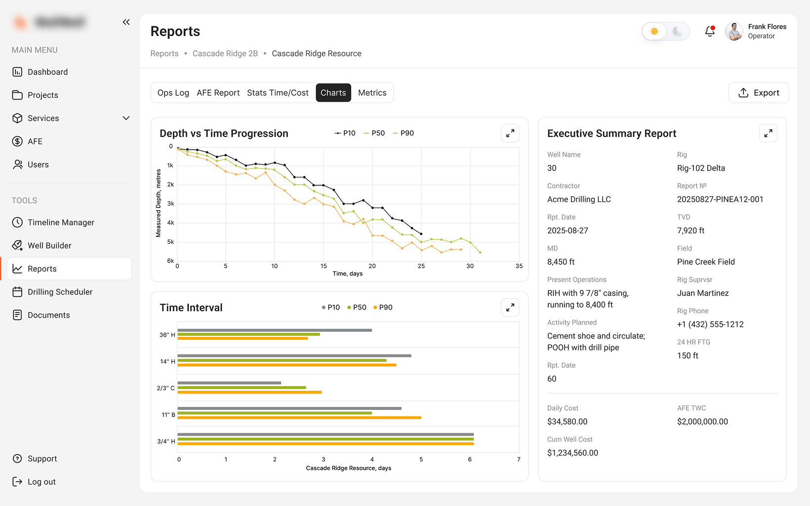
Once a drilling region has been selected, many organizations extend this ecosystem with cloud-based well drilling management software to manage field operations, drilling workflows, and project execution from a single platform.
Read Also Why Off-the-Shelf SaaS Doesn’t Work for Oil & Energy Projects
Build a Predictive Risk Intelligence Platform for Smarter Drilling Decisions
Choosing the right drilling region requires more than analyzing historical reports or isolated events. By combining AI-powered incident correlation, geospatial analytics, and multi-source data integration, organizations can identify emerging risks earlier and make more informed planning decisions.
At XB Software, we develop custom predictive risk intelligence platforms tailored to each client’s operational workflows, data ecosystem, and business goals. Whether you’re building a new EnergyTech product or modernizing existing systems, we can help you turn fragmented operational data into actionable insights. So, if you’re ready to build a predictive risk intelligence platform for your business, contact us to discuss your project.